Green Point
| Bedrock Geology Along the beach, there are almost vertical layers of shale interbedded
with limestone (picture at right). There is also a limestone conglomerate
present (shown at the far left of the image). These are all sedimentary
rocks. Also present is a layer of fine-grained sedimentary rock that we
initially thought to be formed from dried mud. This assumption is based
on the presence of what appears to be mud cracks (see picture below).
All of these rocks form from relatively deep marine deposits. During the
Taconic Orogeny, the closing of the ocean basin these sediments were deposited
on, these rocks were thrust up above sea level while being folded and
faulted. This is why the rock is turned on its side. The type of rock
that underlies these sedimentary rocks is Grenville basement. |
.jpg) |
.jpg)
.jpg)
|
<= Sedimentary rock that looks like soilidified, dried and cracked mud |
| Determining Orientation
of Formation (which way was up when these rocks formed?) To determine this, we looked for evidence of graded bedding. In some of the limestone conglomerate, we found graded bedding with the larger grains present on the right. This indicates that when these rocks formed, the right side of the rock was actually the bottom, because larger grains settle before smaller ones. This piece of information tells us something about what we initially thought to be mudcracks. Notice in the two photos above that what we thought were mudcracks actually exist on the right side of the rock layer. According to the graded bedding, this side of the layer was on the bottom, so what we are seeing can not be mud cracks. It is actually just a result of how the fine grained sediment behaved under the pressure of all the layers above it during the formation of the rock. |
.jpg) |
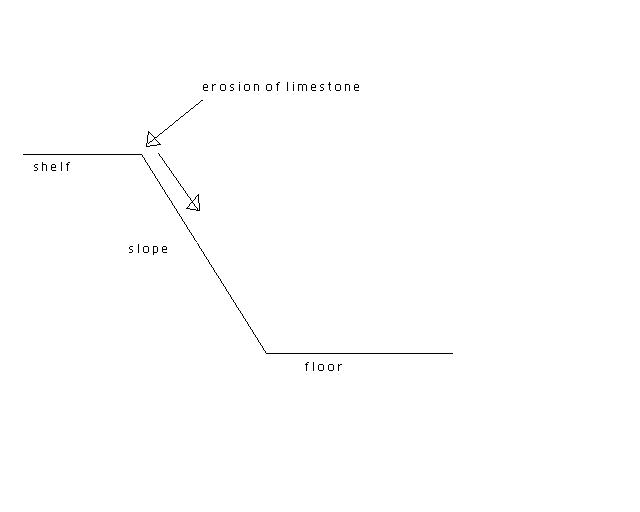 |
Bedrock formation These rocks formed in the deep water at the bottom of a continental shelf. Deep-sea sediments that form shales were deposited in the normal manner. Limestone, which forms from shallow marine deposits, doesnt seem like it should have formed in this type of environment, but it is clearly interbedded with the shale over short periods of deposition. The interbedding occured when limestone eroded from the top of the continental shelf and tumbled down the side into the deep water, grading as it fell. Then, more shale sediments were deposited on top of the limestone, starting the cycle over again. |
| Geologic Significance of Green Point Green Point is geologically significant because it is a World Heritage Site that marks the type section of the Cambrian-Ordivician boundary. This is the only place in the world where the fossil evidence between the two periods is continuous and can actually be viewed. The picture at the right shows the approximate boundary. |
.jpg) |
click on any picture for a larger view